Report on the vegetation of the Andaman Islands by Mr. S. Kurz, Curator of the Herbarium, Royal Botanical Gardens, Calcutta. 1866 Government Printing Office Calcutta. Section 8 describes Andaman subsidence evident in 1858/1866. The bulk of the thirty page report consists of lists of plants. I omit transcriptions of these and earlier sections irrelevant to neotectonics. Kurz was captured by convicts and abandoned, but the details of this episode are not given. This extract was taken from the copy (see pdf) given to the Geol. Surv. India by the Mr Anderson mentioned on the first line.
1. Appointment I was
directed by Mr. T Anderson, Superintendent of the Royal Botanical Gardens,
Calcutta, in accordance with letter No.. 1224 of the Government of India, dated
27th February last, to proceed on board Her majesty's steamer Prince Arthur
to Port Blair, and to collect the material for a flora of the Andaman Islands
and while doing this to ascertain the proportion which trees known to be
valuable for their timber, bear the rest of the forest, and also to identify
botanically all timber that might be shown to me by the local Authorities. I received
also instructions to do all in my power to collect living plants and seeds for
the Botanical Gardens, Calcutta.
 2.
Journal Accordingly I left Calcutta on the
2nd April 1866, and arrived on the 9th of the same month at the place of my
subsequent explorations. Having
placed myself in communication with Superintendent of Port Blair, I began my
excursions on the 16th April, and explored subsequently nearly the whole of the
forest tracts around Port Blair and most of the eastern coast from McPherson's
Straits to Shoal Bay, as also a good part of the western coast as far as Island
Bay before Port Campbell, and visited some of the Labyrinth Islands and
Rutland.
2.
Journal Accordingly I left Calcutta on the
2nd April 1866, and arrived on the 9th of the same month at the place of my
subsequent explorations. Having
placed myself in communication with Superintendent of Port Blair, I began my
excursions on the 16th April, and explored subsequently nearly the whole of the
forest tracts around Port Blair and most of the eastern coast from McPherson's
Straits to Shoal Bay, as also a good part of the western coast as far as Island
Bay before Port Campbell, and visited some of the Labyrinth Islands and
Rutland.
On board
of Her Majesty's Steamer Diana , which
was placed at my disposal for a couple of days, I obtained an opportunity to
proceed to the entrance of Middle Straits, when I explored both the coasts of
South and Middle Andaman as far as the western entrance of the said Straits.
On the
11th May, however, when on the point of entering the interior of South Andaman
from Escape Bay, I
was seized by the Burmese convicts, whom the Supt. of Pt. Blair had given to
assist me in my work, and was tied hand and foot on the ground. These and
subsequent circumstances, which rendered the carrying out of my proposed
excursions through the islands impracticable, obliged me to return on
Her majesty's Steamer Feroze to
Calcutta, where I arrived on the 20th July last.
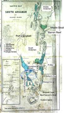
The little sketch map
(Appendix A) of South Andaman shows partially the parts visited by me, and also
the large extent of coutry remaining still to be explored.
3. Unfavorable time of the deputation.......
4. Duration of deputation too short for full exploration........
5. Geological Features of South Andaman and Adjacent
Islands*
The whole of S. Andaman and Rutland is a hilly country
traversed by narrow and steep ridges of no great height, and encircled by a
complete barrier reef, on which a line of breakers is foaming during the rise of the tide.
These dangerous reefs are formed chiefly from Caryphyllia, Madrepora,
Porites, Meandria and other reef forming
corals. Between high and low water
mark there exists in some places a swampy mass formed by a large number of
yellow and flesh colored carnous sponges, covering the coral reefs, and exhuding
a disagreeable smell in the neighbourhood.
The principal ranges all run from south by west to north by east , thus
somewhat in the direction of the lines of out-crop of the different
strata. They are most developed
along the eastern coasts, where they attain sometimes a height of 1200-1300
feet, sending out numerous spurs to the sea. Ford Peak on Rutland island may perhaps exceed 200 feet in
elevation and the Saddle Mountain in North Andaman is rather more than 3000 feet
high. Towards the western coasts they gradually become lower; and nowhere on
that coast are higher ridges observed than from 200-300 feet elevation, bounding
usually fertile valleys of comparatively large size. Some isolated hills, however, may be seen further inland, which I estimate to be between
500 and 600 feet high.
The whole surface appears to be intersected everywhere by numerous steep
ravines, which open out in all directions, and cause great difficulty in
penetrating to the interior parts of the islands, which, I suppose, in general
at very low level.
The hills and ridges rise very precipitously along the sides towards the
sea, commonly at an angle of about 43° to 45° and often at far more. On their sides , towards the interior,
this angle is generally reduced to 20° or 25° but exceptions can be seen
everywhere.
The geological formations of S. Andaman , as well as the southern parts
of Middle Andaman, is, as Mr. W. Blanford , Dep. Supt. of the Geol. Surv. of
Madras informed me, quite identical with those of the Arracan coast. (Footnote:
For the determination of the rocks and other communications, I am indebted to
Dr. Stolickza and W. Blanford, of the Geol. Survey of India).
Chloritic
Rock.- A broad strip of an indurated
chloritic rock, probably of some kind of greenstone or trap, pervades the
interior from Mangrove Bay and Watering Cove northwards in the direction of the
higher ranges of the eastern coast and reaches the eastern sea shores at Middle
Andaman. The same rocks appear also on Termoklee Island (one of the Labyrinthe Islands),
where they come into contact with coarsely stratified serpentine rock. This indurated rock appears to be
rather felspathic , it is of greenish color, scarcely stratified, but
intersected by veins of quartz and calcareous spar. Small cavities occasionally occur in the rock, exhibiting on
the interior walls a large number of quartz crystals and other minerals. It is remarkable that, so far as my
observations allow me to judge , this green rock appears to occupy the greater
part of the level lands, but it does not form ridges or hills of any of any
height worthy to be noted; but we know, in fact, nothing about the formation of
the hills in the interior parts.
Sandstone.- The next rock, which covers a great area of South
Andaman is a grey sandstone, dipping
north by west with an angle of from 43 to 45°, or thereabouts. This sandstone is throughout of a very
fine grain, showing a large proportion of silica, and occasionally being rather
micaceous. The strata exhibit
usually a distinct cubic structure,
The rock itself decomposes easily, and forms in general a good clay
soil.
Along
the western coast of Port Mouat this rock is excavated and variously worked out
by the sea , exhibiting there many fantastically formed rocks resembling in
appearance the limestone rocks on the Mingan Islands.
Often,
as for instance very finely on Bird island near Viper, this sandstone is interlaid in thin layers,
colored rusty by oxide of iron.
Serpentine Rocks-
Serpentine rocks are found chiefly to the south of Corbyn's cove in a
south-western direction, and including nearly the whole eastern part of Rutland
Island, (but also occurring on Ternoklee Island). This formation is easily traceable along the coast by the
reddish color of the rocks , or by
the brick colored soil, which originates from the decomposition. The strike and dip are in general the
same as that of the grey sandstone.
At
Birds-nest Cape, where these rocks attain a height of 70 ' or more, a cubic
structure, similar to that of the common grey sandstone, can be observed.
The unaltered rock is mostly of deep green color, as impure serpentine
rocks usually are . The stratified
portion of the rock, however, which is much more decomposed, exhibits chiefly
a reddish brown color, and is very
ferruginous in some places. It
would be, perhaps, worth smelting, but I saw no limestone at hand.
Behind
Humphray's Ghaut, a narrow strip of serpentine is met with, which might also be
usefully employed for practical purposes. It is tolerably pure and quite soft,
so as easily to be cut with a knife.
At
McPherson's Straits a dark green variety of serpentine rock, with dialage is
see, not only in isolated rocks in the sea, but also on the low ridge of the
coast,
Syenite:- A
microcrystalline syenite has been traced near Watering Cover. It seems to be only of very limited
extent, and surrounded everywhere by the indurated chloritic rock.
Conglomerates, formed of coarse pebbles of quartz, chloritic
serpentine and sandstone, have been observed in large quantities at Muddy
Creek, at Shoal Bay, and on Termoklee Island. They occur principally in the sea.
No
fossils whatever have yet been observed on the Andaman Islands.
Barren
island is an active volcano, about 50 miles distance from Port Blair and already
too well known to need further remarks upon it.
Narcondam island has an extinct volcano remarkable for the great height
of its cone, being twice as high as the outer wall. Owing to the great height of the cone (perhaps 2000 feet),
in proportion to the surrounding wall, this island must have sunk very much, or
the volcano must have been formed from a considerable depth in the sea.
6. The diversity of the soil.....
7. No veins of metals have been observed....
8. Probable sinking state of the Andaman Islands (footnote: In Darwin's map the
Andamans are noted as "rising").
When
approaching the Middle Straits from the south, a narrow reef can be observed
(Barren Reef) at the entrance of the same, extending from the sea from South
Andaman in a nearly easterly direction.
This reef is covered with dead and bleached trees, variously damaged by
the influence of storms and weather.
The first impression is accordingly that all these trees have been
destroyed by the influence of the north east monsoon. I observed, however the same phenomena along the whole
length of the Straits, both on the reefs as well as in the mangrove
swamps. Old trunks appeared from
time to time in the sea, with their roots still attached to the ground. I find
also the same phenomena was report of the Andaman Committee [Rec. Govt.
India, XXV, Section
157]. This induced me to examine this peculiar
feature more carefully, and I landed for this purpose at different places on
both coasts of South and Middle Andaman. Some of the stumps of the trees proved
to belong to such species as never grow in the mangrove swamps, nor in any
locality such as that in which they are now standing. They appeared to me to belong to Pongamia, Erythrina ,
Thespesia and even stumps of Bruguiera
pymnorrhiza were frequent, and of a larger
size than which grow close to the shores, but apparently agreeing with those
which are everywhere found further up the creeks. All these (except the last mentioned) are trees which never
occur in the mangrove swamps, but in a sandy soil just behind them, or else
bordering the sea where the shores are very steep and not adapted for the
formation of mangrove swamps. This
latter circumstance, however, cannot be the case here, the shores at the places
where I made the observations being level for some thousand paces inland.
A
more evident fact proving the sinking state of these islands can nowhere be
seen more clearly than in these Straits.
One can there trace in several places the stumps of the sunken trees in
the sea up to the state where the trees are just dying by the influence of the
sea water, and the subsequent change of the soil by the formation of the
mangrove swamp.
 The sinking state of the
islands is further shown by another fact recorded in the report of the Andaman
Committee, dated 1st January 1858, in Sections 8 and 9. There it is stated that the sea
encroached some 40 or 50 feet since the first settlement at Catham Island in
Port Cornwallis, so that the store house that stood there has been destroyed by
the sea since the abandonment of the place in 1796. An examination of the spot and of the documents relating to
that Settlement might give us some guide to determine the rapidity with which
these Islands are becoming submerged.
The sinking state of the
islands is further shown by another fact recorded in the report of the Andaman
Committee, dated 1st January 1858, in Sections 8 and 9. There it is stated that the sea
encroached some 40 or 50 feet since the first settlement at Catham Island in
Port Cornwallis, so that the store house that stood there has been destroyed by
the sea since the abandonment of the place in 1796. An examination of the spot and of the documents relating to
that Settlement might give us some guide to determine the rapidity with which
these Islands are becoming submerged.
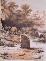
Figure left is from the 1858
Andaman Committee report showing the abandoned store house remaining from 1796.
Lt. Jameson, of
Catham Island, has informed that a similar encroachment of the sea is taking
place [as] at that Island in Port Blair.
Andaman Straits which is impassable at
low water for boats, will perhaps afford another good proof of this
subsidence. I had no opportunity
of visiting these Straits. McPherson 's Straits owing to its more abrupt coasts
, does not exhibit this phenomenon , as far as I was enabled to ascertain. It is also a matter of great interest
to decide the question whether the rapidity of the submersion takes place
equally through the whole group of Islands or rather whether it is a decreasing
one towards the northern extremities.
Dr.
Mouat, in his able account of the Andaman Islands (selections from the Govt. of
India, XXV) maintains quite a contrary view of this subject, as is shown in his
preface where writing about the Andaman Islands he says-"They are collections of Islands surrounded by most
dangerous coral reefs, which are gradually forming innumerable Islands as each
becomes lifted above the surface,"
etc.
Dr. Von
Liebid (in the same Records p. 127) points to a probable rising of Barren
Island, recording thus "One of the most
remarkable amongst these was a stratum of rounded stones, like large pebbles,
cemented by tufa, exactly like those of the present beach, but at a
considerable elevation (about 20 feet) above the high water mark, showing that
the sub-marine base of the Island must have been raised since those pebbles had
been washed by the sea".
Dr. Playfair (C. p 123), however , says -"I could not after very careful examination, satisfy myself that
there had been any recent upheaval of the islands, none of the rocks exhibiting
signs of having been water worn".
It may
be remarked that Barren Island is an active volcano, therefore, probably rising
and sinking.
From a practical point of view, the fact of a sinking state is of
importance as we see all along the shores small fertile valleys opening toward
the sea , and preparing themselves gradually for mangrove swamps.
Suppose the gradual submersion to be one foot in a hundred years (which is a rather low
estimate) we should see in a thousand years all the shores and houses along the
beach at Ross Island and Middle straits submerged while so many harbors now
dangerous would become open for navigation.